Exploring the Sealion Cove Trail

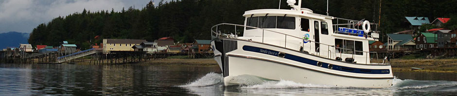
My father mentioned that we planned to explore the Sealion Cove trail this summer. Planning to fish for king salmon in Salisbury Sound makes Kalinin Bay the obvious anchorage, where the trail head is found. This plan was to be realized, Tamara and I hiked the cove one grey afternoon and had a lot of fun doing it.

I have been to the lake and back years past, but the group I was hiking with was not ready to go the full distance to the beach at Sealion Cove. This is not a place to hike alone. We ended up turning around after enjoying the scenery at the lake. This time I really wanted to go all the way.

Sealion Cove Trail

The first section of trail along the top of Kalinin Bay

The first section of the trail follows the shore of the wide estuary that drains into Kalinin bay. The trail follows the treeline where the high tides and saltwater prevent the spruce from encroaching further. While there has been some effort to improve the trail here, with gravel spread and rock strategically placed at the many small streams, the effort looks to be futile. Deep mud pockets sucked at our feet and required careful footing. The dry socks in my pocket were obviously going to stay in my pocket, my river sandals often full of mud.

Sealion Cove Trail

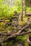
A section of typical trail covered in tree roots

The trail is only 2.5 miles each way, but the distance does not measure the difficulty here. Much of the trail is deep mud, slippery rocks, tree roots or worse. You are constantly stepping up, over, onto, or out of something. As a result your ankles and calves take a pounding. Tamara and I were constantly helping each other up and over, or retrieving a shoe sucked off by the mud. I would give the difficulty a 2x multiplier, making the five mile round trip equivalent to ten on a clear trail.

Tamara on Boardwalk

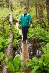
Tamara on a boardwalk section of the Sealion Cove Trail

Large sections of the trail cross muskeg, the mossy swamps that are so common in southeastern Alaska. Muskeg occurs wherever there is more rainfall than can drain away, leaving the soil too saturated for the forest to claim these spaces. The trail builders have placed large sections of boardwalk to allow you to cross these sections. The boardwalk does have its risks as well, the boards are very slippery and in places have begun to sink into the swamp. More than once I caught myself as the treacherous footing betrayed me.

Muskeg

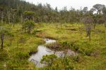
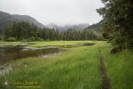
A muskeg meadow along the Sealion Cove trail

The muskeg is beautiful! Small lily covered ponds among stunted spruce trees makes whole sections of the trail seem like you are walking through some fantastic garden designed by a master gardener. Small wildflowers, including orchids, were scattereed across the mossy meadows.

Sealion Cove trail map

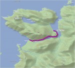
A map of the trail to Sealion Cove

A lake marks the halfway point, in the pass between a pair of two thousand foot high mountains. A well placed bench can be found where the trail meets the shoreline. The eastern end of the lake is quite shallow, you can wade far out and be no more than knee deep. Come late summer this will be rich with lily pads. There are beautiful boulders along the shoreline covered in moss and stunted spruce trees that would be right at home in a Japanese garden.

From the lake you progress quickly downhill, losing the 500ft elevation gain to arrive at a coastal wetlands. It hardly seems possible but the trail just gets more beautiful here, with muskeg ponds and small streams crisscrossing the trail. As you reach the coast you pass through a grove of old growth spruce deep in moss.

Spruce & Cedar

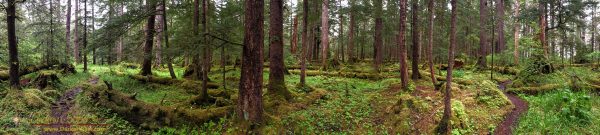
A mossy grove of spruce and cedar near Sealion Cove beach

The beach is very much worth the trek through the mud to reach, a perfect crescent of sand over a mile long and looking out to the open Pacific Ocean. A gentle surf was rolling in as we waded out into the water to validate our arrival at the Pacific, a cloud of gulls wheeling about us.

I started taking photos and Tam set off for some beachcombing. Having no deadline other than getting back before dark we were in no hurry to begin the return journey. The worst that would happen is that we would miss supper, no problem.

Sealion Cove

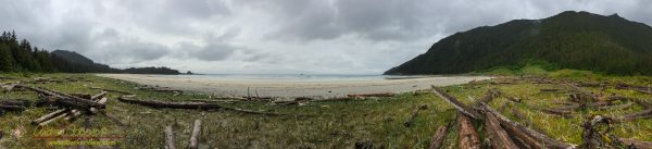
Sealion Cove beach on Kruzof Island

Pleasantly we were able to keep in radio contact with the boat the entire way, informing them of our progress. The handheld VHF radio I carried easily able to communicate with the boat radios despite a two thousand foot mountain directly between us. I am sure this help alleviate my father’s worry about us.

Reluctantly we began the trail back, climbing back through the mud and roots, carefully negotiating the boardwalks. My second and only remaining camera battery starting to wane. The bench at the lake a nice resting spot to break the return journey. As we reached the beach in Kalinin Bay we found that my father was waiting with the launch, back to the boat and a warm dinner.

About Andrew Cooper

An electrical engineer living and working on Mauna Kea, Hawai'i. Webmaster for the NordicQuest.com website. Sometimes the first mate/deckhand/launch driver/anchor detail/cook/dishwasher and mechanic aboard the Nordic Quest.
This entry was posted in Places and tagged , , , , , . Bookmark the permalink.

Leave a Reply

Your email address will not be published. Required fields are marked *

This site uses Akismet to reduce spam. Learn how your comment data is processed.